Quantitative mapping of dolomitization using close-range hyperspectral imaging: Kimmeridgian carbonate ramp, Alacón, NE Spain
| dc.contributor.author | Kurz, Tobias Herbert | |
| dc.contributor.author | Miguel, Galo San | |
| dc.contributor.author | Dubucq, Dominique | |
| dc.contributor.author | Kenter, Jeroen | |
| dc.contributor.author | Miegebielle, Veronique | |
| dc.contributor.author | Buckley, Simon John | |
| dc.date.accessioned | 2023-03-30T12:37:30Z | |
| dc.date.available | 2023-03-30T12:37:30Z | |
| dc.date.created | 2022-08-23T14:08:28Z | |
| dc.date.issued | 2022 | |
| dc.identifier.citation | Geosphere. 2022, 18 (2), 780-799. | en_US |
| dc.identifier.issn | 1553-040X | |
| dc.identifier.uri | https://hdl.handle.net/11250/3061193 | |
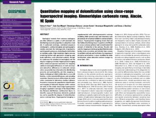
| dc.description.abstract | Geological models from outcrop analogues are often utilized as a guide, or soft constraint, for distributing reservoir properties in subsurface models. In carbonate outcrops, combined sequence stratigraphic, sedimentological, and petrographic studies constrain the heterogeneity of geobodies and diagenetic processes, including dolomitization, at multiple scales. High-resolution digital outcrop modeling further aids geometric mapping, geobody definition, and statistical analysis, though its usefulness for detailed mineralogical and lithological mapping is limited. Hyperspectral imaging offers enhanced spectral resolution for mapping subtle mineralogical differences. In both outcrops and subsurface, differences in carbonate composition can provide key information for distributing porosity and permeability, yet this mapping is highly challenging in field studies due to access difficulties, visible material differences, and sampling resolution. Spectral analysis of limestone–dolomite ratios conducted in laboratory studies indicates theoretical measures for quantitative identification and mapping of dolomite degrees within carbonate rocks. In this study, close-range hyperspectral imaging is applied to outcrops of the Alacón Member, Barranco del Mortero, northeastern Spain, to identify exposed limestone–dolomite geobodies and to quantify the degree of dolomitization across outcrop faces. Hyperspectral imaging is supplemented with photogrammetric outcrop modeling, field spectroscopy, and laboratory sample analysis for empirical validation and uncertainty analysis. Hyperspectral mapping shows that earlier fieldwork utilizing visual inspection of difficult to access outcrop surfaces had overestimated the amount of dolomite in the outcrop. Results indicate that hyperspectral imaging identified dolomite bodies more accurately and reliably than conventional field methods and facilitates the mapping of dolomite contribution in areas modified by dedolomitization, where dolomite content changes by more than ~20%. | en_US |
| dc.language.iso | eng | en_US |
| dc.rights | Navngivelse-Ikkekommersiell 4.0 Internasjonal | * |
| dc.rights.uri | http://creativecommons.org/licenses/by-nc/4.0/deed.no | * |
| dc.title | Quantitative mapping of dolomitization using close-range hyperspectral imaging: Kimmeridgian carbonate ramp, Alacón, NE Spain | en_US |
| dc.title.alternative | Quantitative mapping of dolomitization using close-range hyperspectral imaging: Kimmeridgian carbonate ramp, Alacón, NE Spain | en_US |
| dc.type | Peer reviewed | en_US |
| dc.type | Journal article | en_US |
| dc.rights.holder | © 2022 The Authors | en_US |
| dc.description.version | publishedVersion | en_US |
| cristin.ispublished | true | |
| cristin.fulltext | original | |
| cristin.qualitycode | 1 | |
| dc.identifier.doi | 10.1130/GES02312.1 | |
| dc.identifier.cristin | 2045404 | |
| dc.source.journal | Geosphere | en_US |
| dc.source.volume | 18 | en_US |
| dc.source.issue | 2 | en_US |
| dc.source.pagenumber | 780-799 | en_US |
| dc.relation.project | Norges forskningsråd: 266740 | en_US |
| dc.relation.project | Andre: TotalEnergy SE, laboratory at CSTJ | en_US |
Tilhørende fil(er)
Denne innførselen finnes i følgende samling(er)

Med mindre annet er angitt, så er denne innførselen lisensiert som Navngivelse-Ikkekommersiell 4.0 Internasjonal